The last two months have been very productive for Marinus Link, from formalising our Gippsland stakeholder liaison group, to field and marine surveys, webinars, along with the submission of the environmental referrals to the Commonwealth and the Victorian governments for assessment. We are pleased to share with you our updates in this newsletter. We welcome your questions, and encourage you to keep in touch with us, either in person at our upcoming events, or via our website and social channels.
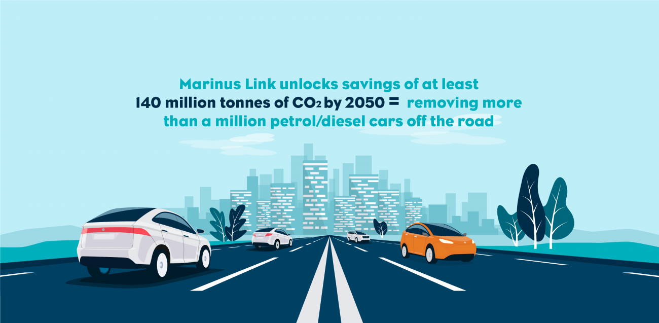
Marinus Link is a critical part of the future National Electricity Market and has been declared a national priority project by Australian Energy Market Operator and the Commonwealth. It will put downward pressure on energy prices, help reduce emissions and create new jobs in Victoria’s Gippsland region and in North West Tasmania. It complements and supports low cost, reliable and clean energy from a range of energy sources including solar, wind, hydro, pumped hydro storage and green hydrogen production.
Gippsland Stakeholder Liaison Group gets underway
The Marinus Link Gippsland Stakeholder Liaison Group (GSLG) will meet for the first time in November 2021. The GSLG will provide a forum for us to provide information about the project, discuss potential impacts and opportunities and seek stakeholder perspectives on a range of matters related to Marinus Link, including our economic development plans. The group will include representatives from state government agencies, councils, local economic development bodies, education providers and industry groups.
The GSLG will be chaired by Jane Leslie, a Gippsland local business owner who has been involved in Regional Development Australia’s Gippsland committee and previously chaired the West Gippsland Health Group. The Marinus Link team welcomes Jane to the role and looks forward to working with her and the other GSLG members
Environmental assessment process kicks off
Marinus Link is a complex project which must go through environmental and land use planning impact assessment processes. Certain sections will activate legislation that is overseen by the Commonwealth Government, while other sections will activate legislation and policies managed by state and local governments.
In September 2021, Marinus Link submitted environmental referrals for the project under the Commonwealth Environment Protection and Biodiversity Conservation Act 1999 (EPBC Act) and the Victorian Environment Effects Act 1978 (EE Act).
Update on environmental referral under EPBC Act:
On 4 November 2021, a delegate of the Minister decided that the proposed action is a controlled action and requires further assessment and approval under the EPBC Act before it can proceed. The proposed action will be assessed through an Environmental Impact Statement.
The environmental referral under the Victorian EE Act is currently undergoing review to determine the extent of environmental assessments that will be required.
Answering your questions – environmental assessment process
What is an environment and heritage assessment process?
All projects which have the potential to have an impact on the environment, or on Aboriginal or cultural heritage values, must obtain the necessary approvals from the relevant authority. Approvals can be required at the local, state or Commonwealth level and may be required from multiple authorities.
How does the environment and heritage assessment process work?
Each environment and heritage assessment process is slightly different, so we recommend visiting marinuslink.com.au/environmental-assessment-and-planning-processes for more details. The general EPBC Act and EE Act process is as follows:
The project is referred to the relevant authority using desk-top studies (and in some cases actual field or marine study data). This step helps determine what assessment processes should apply to the project based on likely or known impacts.
- Should the relevant authority decide that the project requires further assessment, they will issue guidelines on the scope of investigations the project needs to undertake during the assessment process.
- The project will then undertake investigations to better understand how the project may impact the environment and Aboriginal and cultural heritage values, and propose measures to avoid, mitigate or offset impacts.
- What preliminary environmental or cultural heritage studies were done as part of the referrals?
Desktop studies have been completed for both land and marine environments to understand if any plants, animals or heritage sites of value exist within the project corridor. Some surveys have taken place to validate the desktop studies, including a benthic marine study which looks at seabed habitats.
How can the community provide feedback about the project?
During the environmental, land use planning and heritage assessment processes, there are formal and informal opportunities for community consultation.
Community consultation opportunities will also be advertised in our monthly e-news, in local papers and on our website. We also encourage you to sign-up for project updates here: www.marinuslink.com.au/contact-us-2.
In the field
Some activities that were scheduled to take place in August and September 2021 were paused due to COVID-19 restrictions, but we are back in the field again in November 2021.
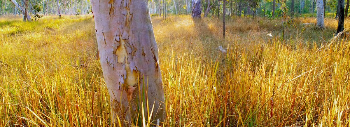
Over the coming months, you may see our specialist consultants undertaking field surveys on behalf of the Marinus Link team on some properties and public land along the proposed route, and on the roadside between Waratah Bay and the Hazelwood area. We arrange access to private properties directly with landowners.
Ecology field surveys started again on Monday, 15 November 2021. These involve ecologists walking along the proposed route to record plants, animals and habitat. They record information by taking photographs and taking detailed notes.
Non-intrusive geotechnical field surveys will also be ongoing throughout late 2021 and early 2022. These investigations help us to understand more about the local area and environment in order to refine the proposed route and determine the most appropriate construction methods.
As with all our activities, our land agents, surveyors and other field-based staff have COVID-19 safe plans and adopt COVID-19 safe practices.
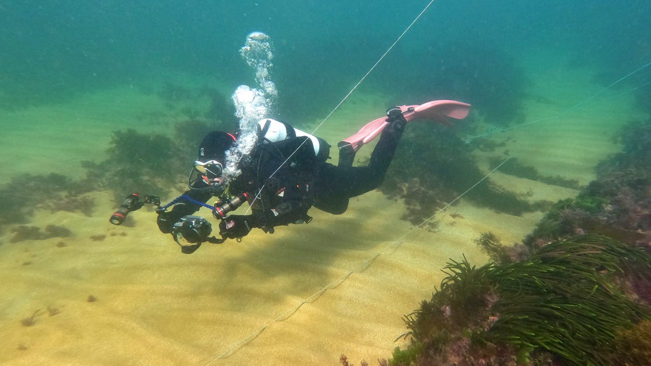
Diving into marine surveys!
Departing Beauty Point in Northern Tasmania in late August 2021, we undertook a marine benthic ecology survey in the Tasmanian nearshore environment and offshore in Bass Strait. This survey was undertaken to help us determine the locations of sensitive seabed habitats such as reefs, outcrops, sponge gardens and seagrasses. This survey will also help us to determine how to avoid or minimise the impact of Marinus Link on the marine environment.
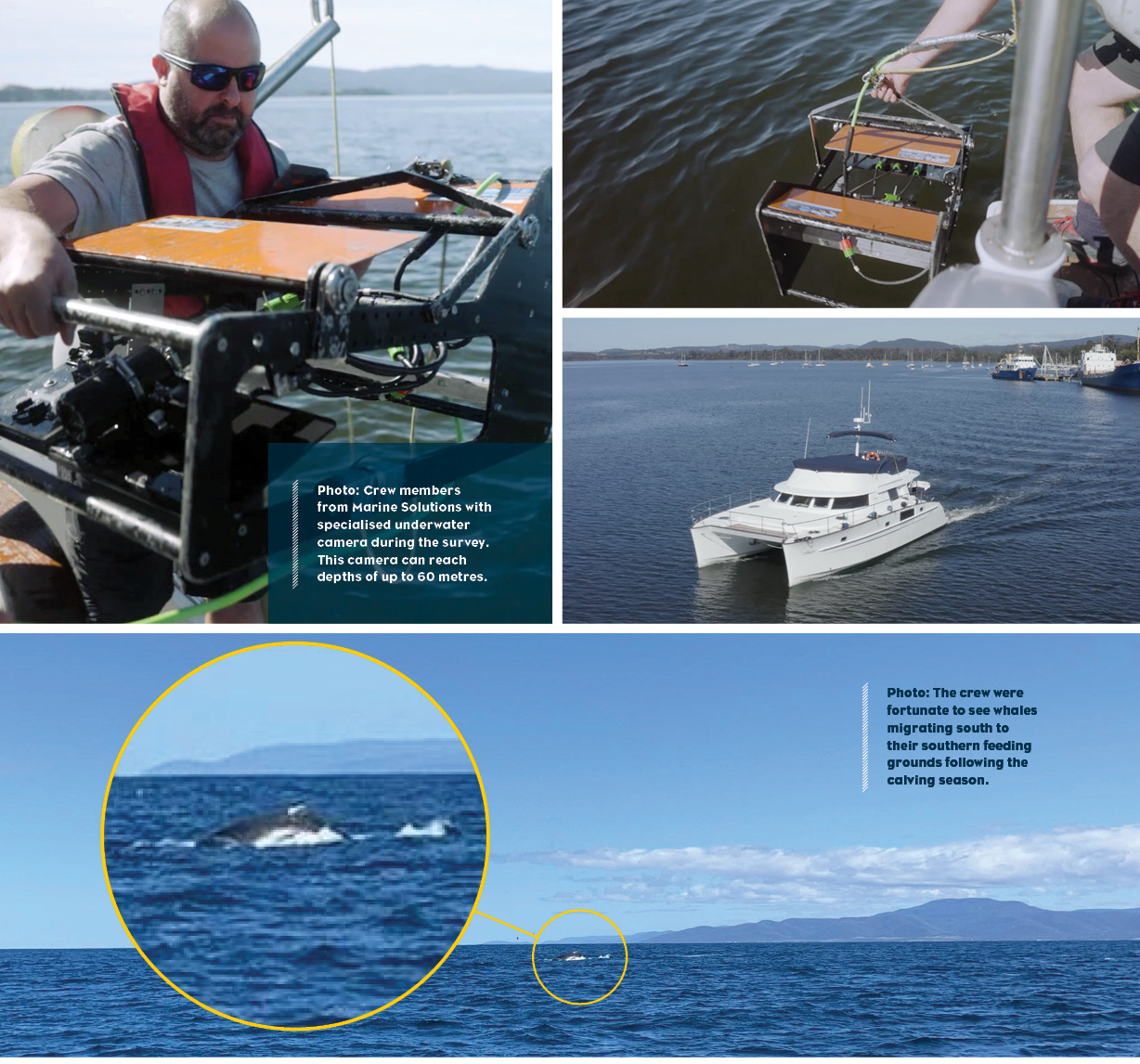
The benthic ecology survey involved towing an underwater camera (above the seafloor to avoid disturbance) to capture video recordings and still images of the seabed habitat.
In late September 2021, we were back in the brisk waters off the Tasmanian coast near Heybridge, just east of Burnie, this time conducting a maritime heritage and archaeology survey. One item found of particular interest was a block-like structure, which is currently being studied to see if it holds any heritage value. This survey, like many others we undertake, will provide important scientific data that will inform the rigorous environmental and technical assessment processes that will enable us to sensitively build Marinus Link. A big thanks to the crew at Marine Solutions for facilitating these activities and assisting our specialists with the surveys.
Marine benthic ecology and maritime heritage and archaeology surveys are due to commence in the nearshore environment of Waratah Bay, Victoria, in late November 2021 (weather permitting).
Summer events
With COVID-19 restrictions set to ease over the coming weeks, we are planning to get back out into the community to chat about the project and answer questions from the community.
This spring and summer, please come look for our stall at the following markets:
- 27 November, 8am to 1pm, Traralgon Farmers Market
- 18 December, 8:30am to 1:30pm, Leongatha Community Market
We recommend checking our website prior to heading out, as any event changes due to COVID-19 will be listed here: marinuslink.com.au/community
We look forward to hopefully seeing you all safely in person again!
Working with host landowners
An easement is needed for the underground cable that will run between Waratah Bay and the greater Hazelwood area. Discussions are currently being held with relevant landowners to obtain access to undertake field surveys to assist in An easement is needed for the underground cable that will run between Waratah Bay and the greater Hazelwood area.
Discussions are currently being held with relevant landowners to obtain access to undertake field surveys to assist in determining the preferred route. We are providing a one-off payment to landowners in recognition of the temporary inconvenience of this planned survey work. Based on the results of the surveys, if properties prove favourable to host Marinus Link assets, we would commence easement negotiations with landowners that would attract further payments from the project.
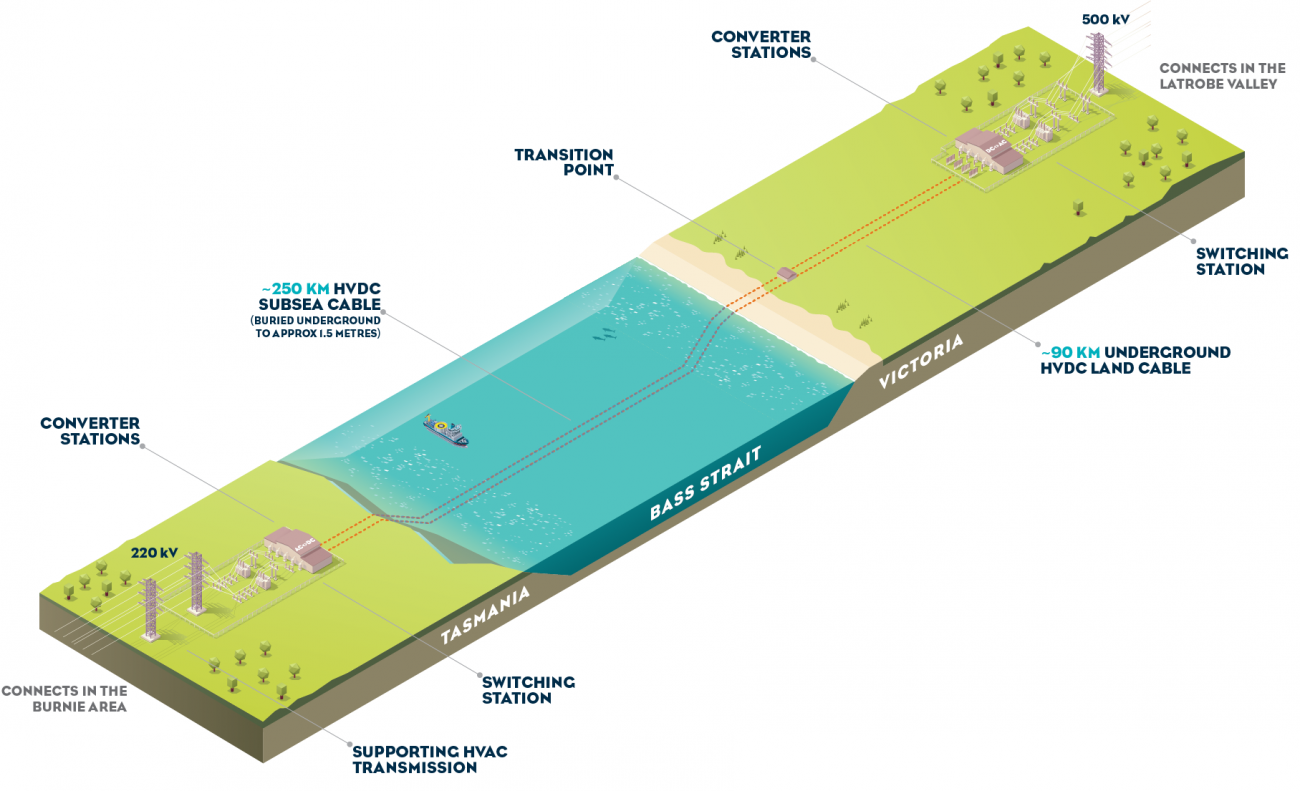
What is Marinus Link?
Marinus Link is a proposed 1500 megawatt (MW) capacity underground and undersea interconnector between Victoria and Tasmania. It is supported by over 230km of transmission developments in North West Tasmania. Collectively, these projects are known as Project Marinus.
The project will provide Victoria and other states across the National Electricity Market (NEM) with access to Tasmania’s significant dispatchable renewable energy generation and storage resources, keeping lights on, reducing emissions, creating jobs, and putting downward pressure on prices right across the NEM.
Who is Marinus Link?
Marinus Link is currently being progressed by TasNetworks with funding support from the Tasmanian and Commonwealth governments. TasNetworks is a government business wholly owned by the State of Tasmania. Under a Memorandum of Understanding between the State of Tasmania and the Commonwealth, a new Special Purpose Vehicle is being established to progress the project, which will be either majority or wholly owned by the Commonwealth of Australia.